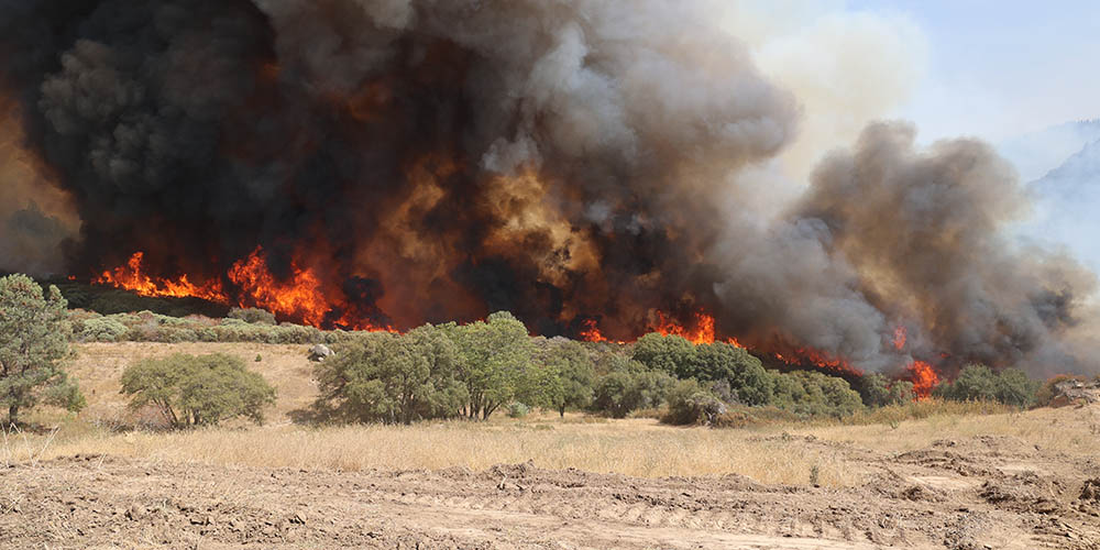
(Photo: CAL FIRE/Flickr)
In the South Lake Tahoe area, more than a dozen years of hard work and collaboration helped save residential areas from a terrible fate during this year’s wildfire season.
The evidence can be seen in maps showing where this summer’s massive Caldor Fire burned – and where it didn’t. Extensive pre-fire interventions helped firefighters in their efforts to save many threatened homes and structures in the South Lake Tahoe area. These efforts included vegetation thinning and prescribed fire to reduce dangerous fuels on the landscape, as well as home-hardening and other measures.
The work stands now as an important template for creating a more safe and resilient state.
“We know what works,” said Steve Frisch, president of the Sierra Business Council. “This isn’t about knowing what to do. It is about resources and the will to take action.”
The preventive strategies in the South Lake Tahoe area took many years and the cooperative work of numerous organizations and individuals. Such strategies are among the approaches to wildfire prevention and resiliency that will be explored during the 2021 California Economic Summit in Monterey on Nov. 9-10. Encouraging investments in these types of approaches has been a key focus of the Summit’s Empowering Productive and Resilient Landscapes work group and will continue into 2022.
This Summit work is led by Frisch of the Sierra Business Council; Glenda Humiston, vice president, UC Agriculture and Natural Resources; and Bill Tripp, director of Natural Resources and Environmental Policy for the Karuk Tribe Department of Natural Resources.
The efforts in the South Lake Tahoe area took hold after an earlier wildfire season. In June 2007, near the edge of South Lake Tahoe, the Angora Fire ignited and raged through wildlands and residential neighborhoods. It destroyed 254 homes and left a terrible path of destruction.
In the weeks and months that followed, land managers and community leaders in the Lake Tahoe Basin mobilized. In 2008, the Tahoe Fire and Fuels Team formed with twin goals of reducing fuels in the “wildland-urban interface” and preparing communities for wildfires. The partnership involves 21 federal, state, and local conservation, land management, and fire agencies, including the U.S. Forest Service and the California Department of Forestry and Fire Protection.
“The Angora Fire was a big wake-up call,” said Milan Yeates, a California registered professional forester and community forestry program supervisor with the California Tahoe Conservancy, a state agency that owns and manages land in the Basin and is part of the Tahoe Fire and Fuels Team. “We didn’t want that to happen again in the Basin.”
Between 2008 and the present, the Tahoe Fire and Fuels Team’s partners collectively treated more than 72,000 acres. The work included hand thinning, mechanical thinning, and prescribed fire including pile burning and understory burning. The works lives on in this Action Plan.
Among the strategies was prescribed fire, which was an integral element to the overall plans for greater safety and resiliency in the Tahoe Basin, and also is an important resiliency component elsewhere in the state.
“Cultural burning and prescribed fire are critical for ensuring greater resiliency in the face of growing wildfires,” said Tripp of the Karuk Tribe. (See this report for more information.)
Alongside these landscape-based efforts, the Tahoe Network of Fire Adapted Communities, led by seven fire districts and the Tahoe Resource Conservation District, focused on neighborhood and individual resiliency, including home hardening, defensible space development, and education around evacuating safely.
On August 14 of this year, the Caldor Fire ignited and put this collection of strategies to the test.
The fire destroyed hundreds of homes in its early days, most in the town of Grizzly Flats. But although the fire ultimately burned more than 220,000 acres, the preventive efforts in the South Lake Tahoe area are credited with preventing catastrophic damage in communities such as Christmas Valley and Meyers. Maps of the Caldor Fire’s perimeter and completed wildland-urban interface treatments show the outcomes: Large tracts of forested lands burned all around residential neighborhoods, but the curving streets with homes and structures were spared.
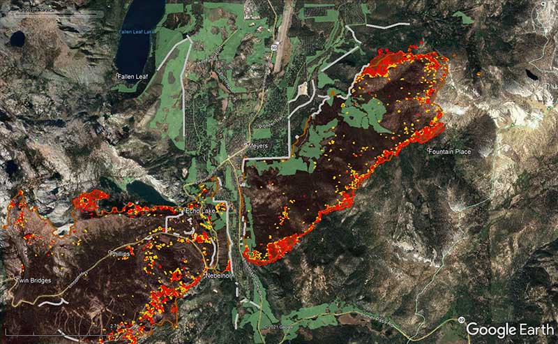

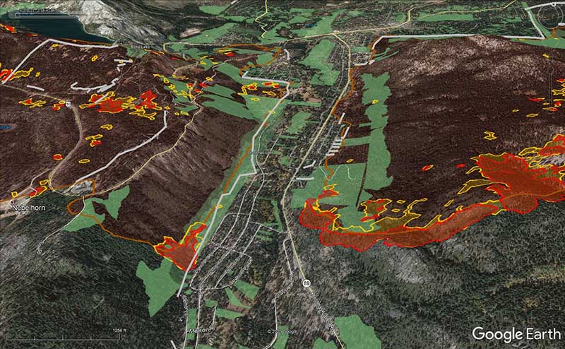
Click on image to view map. Brown areas represent the fire perimeter as of the evening of September 1 and green areas represent completed fuel reduction treatments from 2008 to 2019. Yellow and red show moderate and intense heat, respectively, at 4 a.m. on September 2. Grey is a completed bulldozer line built by firefighters as of the evening of September 1. (Maps by Tahoe Fire and Fuels Team via Google Earth)
Amanda Milici, the Fire Adapted Communities program coordinator for the Tahoe Resource Conservation District, evacuated for two weeks from her home in Christmas Valley in a “surreal experience” and now can see the blackened hillsides from her back yard.
“We had been preparing for this moment for many years,” Milici said. “The work done by residents to protect their own selves and homes greatly contributed to the firefighters being able to save homes. It has been a crucial component.”
“This didn’t happen in the South Lake Tahoe area by accident,” noted Humiston of UC Agriculture and Natural Resources. “We need to be doing this work all over the state.”
This growing understanding around effective wildfire strategies comes against the backdrop of the state’s recent investment of $1.5 billion for wildfire prevention and forest resilience work. The investments are in harmony with the California Economic Summit’s 2019 California’s Wildfire Crisis: A Call to Action, with the state’s Wildfire and Forest Resilience Action Plan, and with the ongoing work of the Resilient Landscapes Work Group through the Summit.
To get involved in this work, join us at the 2021 California Economic Summit on Nov. 9-10. You can register here.